Sturgeon Valley ASP
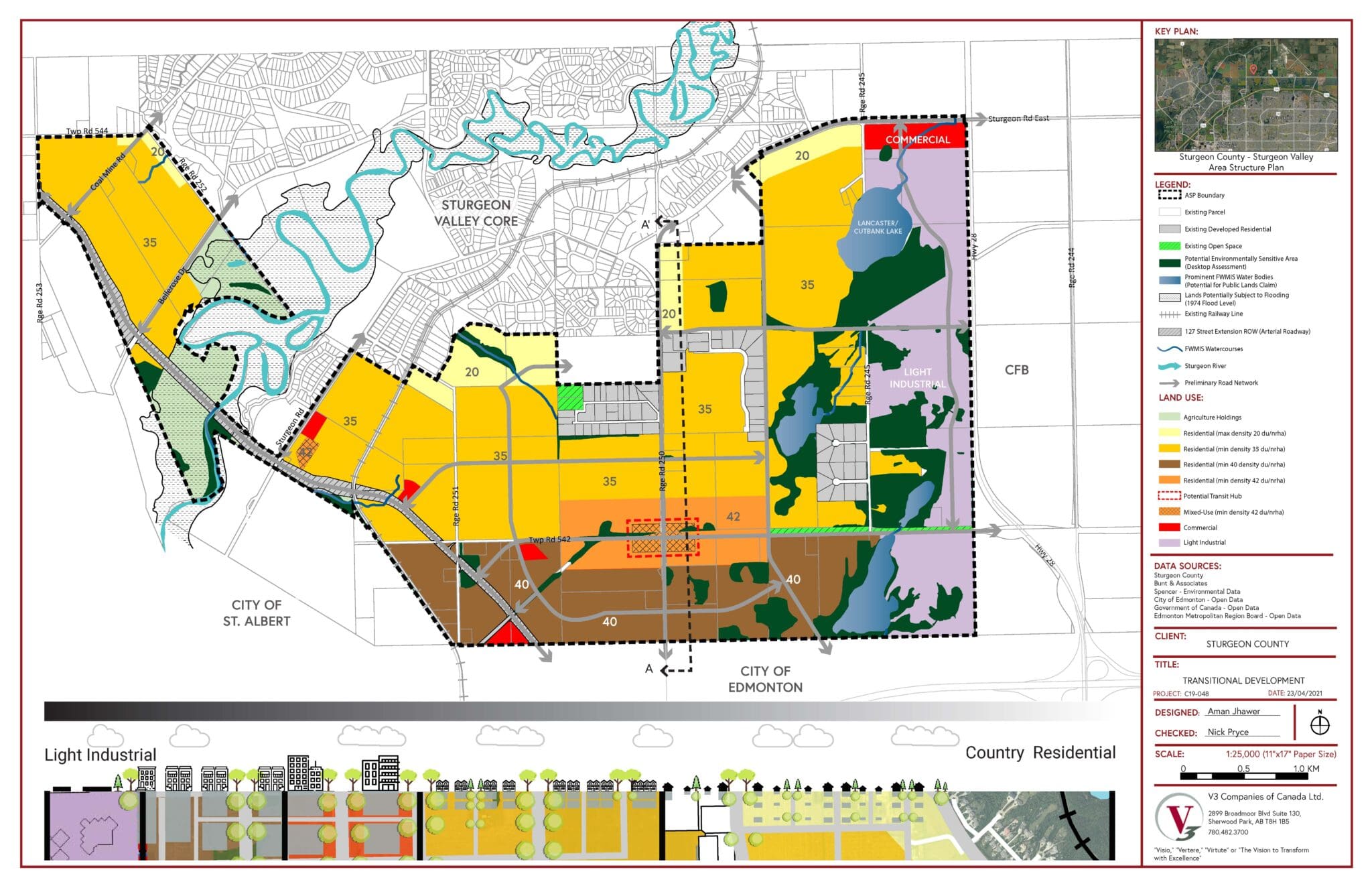
The Edmonton Capital Region recently adopted a growth plan which directed Sturgeon County, its bordering municipalities, and the Canadian Forces Base to collaborate on the development of a special policy area, known as Sturgeon Valley. This unique area includes an established serviced estate lot community surrounded by a rural environment bordering two cities and a major National Army Base, and is projected to accommodate a future population of 70,000+ residents, commercial mixed-use neighborhoods, and a light industrial area. We are working with the County on how to meet varying stakeholder interests, developing a plan for how these land areas will grow over time while addressing the needs of today’s established community.
Project Owner
Sturgeon County
Market Sector
Local GovernmentPrimary Service Lines
Planning, Site CivilRegion
EdmontonAdditional Info
Project Highlights:
- The “Sturgeon Valley Special Study Area” (SVSSA) directs development within an area that borders the City of Edmonton to the south, and the City of St. Albert to the south west, and the Canadian Forces Base-Edmonton to the east. Known as Sturgeon Valley, this area is comprised of almost 20 sections (12,501 acres) governed by the Sturgeon Valley Area Structure Plan (AS)) adopted in 1999. V3 was retained to align planning in the Sturgeon Valley with the over-arching Edmonton Metropolitan Region Growth Plan and the SVSSA. To accomplish this, V3 worked with County administration to develop the new ASP, as well as updating the existing ASP to reflect the changes and new policy directions.
- Key Challenges: working with three Municipalities and various stakeholders that have different perspectives. The development of the special policy area was also a highly political process. Now that the policy is adopted, key challenges relate to land owners who desire quick development, however, the population projections indicate that the build-out could occur over 100 years or longer.
- Solutions: a naturalized stormwater detention basin located on the south side of the Lakewood Estates subdivision which is south of the intersection of Superior Drive and Erie Drive. Situated within the Lily Cache Slough and positioned between the Haley Meadows naturalized detention basin to the west, Mather South Preserve to the east, and O’Hara Woods State Nature Preserve to the south this site is 15.4 acres and has 6.5 acres of open water with an emergent wetland shoreline surrounded by 8.9 acres of wet-mesic prairie.
- Unusual Conditions: when dealing with larger cities, having the key people at the table is critical to success. Unfortunately, an administration staff member is representing the City. This often involved back channel communication to ensure information was being communicated accurately.
Related Projects
Edmonton Metropolitan Region Board
Edmonton Metropolitan Region Board (EMRB) is made up of 13 municipalities that are required to align with multiple regional policy documents that …
Agri-Business Multi-Criterion Decision Analysis
Several companies interested in investing in large agri-business processing facilities posed a potential challenge in their need to utilize as much as …
Five Mile High School Design Charrette
The County of Grande Prairie acquired a quarter section of land to accommodate the expansion needs of the local school districts.
Touch the Water – Clairmont Lake Urban Design
The County of Grande Point aimed to make Clairmont Lake the key feature of its new 20,000-resident community.
